18 Appendix G, Required Certificates (Record of survey for Boundary Line Adjustment), is the City of Las Vegas Department of Planning form of the certificates that appear on a record-of-survey map for a boundary line adjustment. It is not a Las Vegas property tax form, although the Owner's Certificate does have the owners state that all taxes on the lands shown have been paid. Property owners, map applicants and Nevada land surveyors use it to prepare the owner, surveyor, city approval and acknowledgment blocks. On this page you can fill out the form online on FillingPDF and download or print the completed PDF; the original is published by the city at the official URL.
Last updated
What is Appendix G?
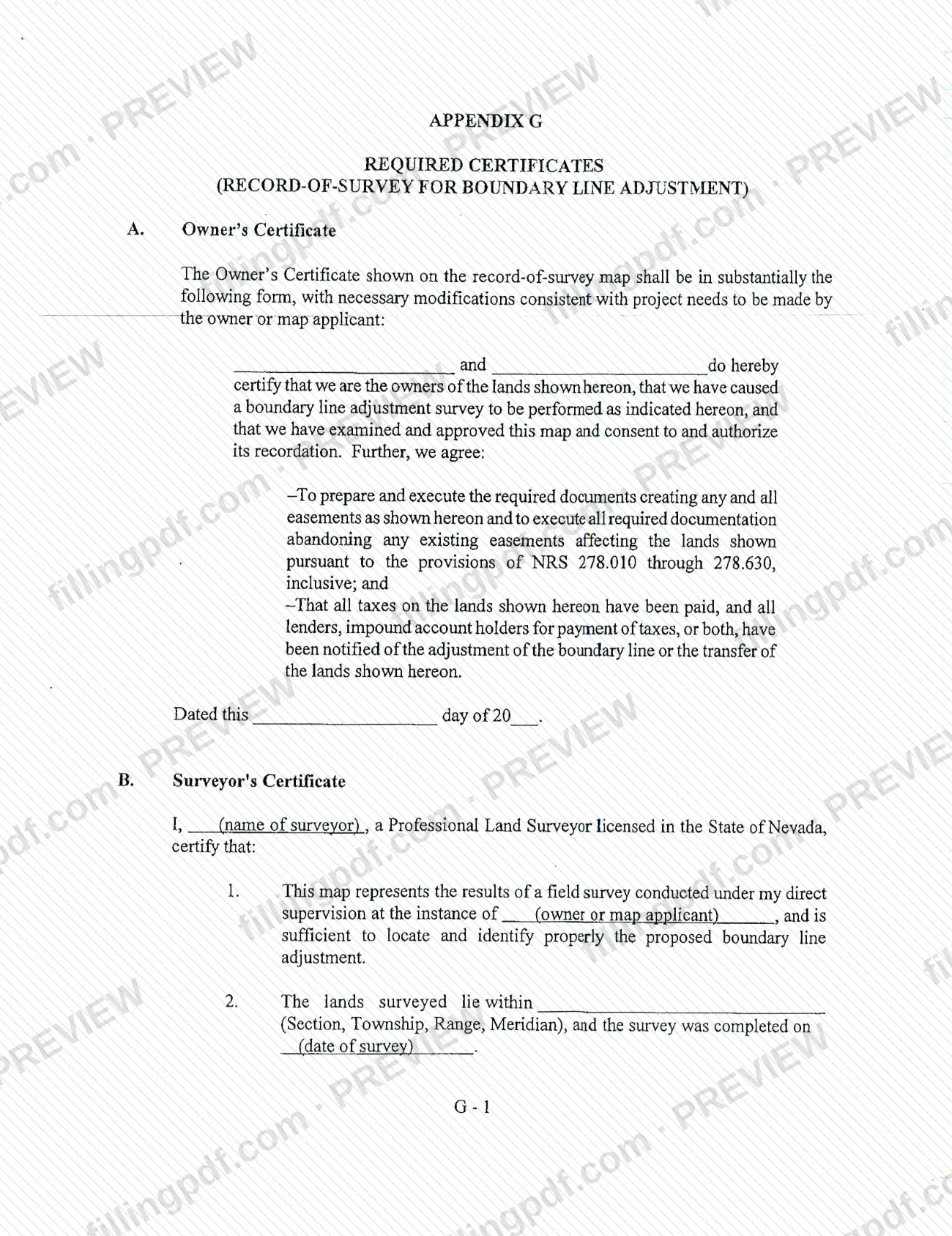
18 Appendix G - Required Certificates (Record of survey for Boundary Line Adjustment) is the City of Las Vegas Department of Planning appendix that gives the wording of the certificates a record-of-survey map must carry when it shows a boundary line adjustment.
The appendix has four parts:
- Owner's Certificate. The owners certify that they own the lands shown, caused the boundary line adjustment survey to be performed, and approve the map and consent to its recordation. They also agree to prepare and execute the documents creating any easements shown, to execute documents abandoning existing easements under NRS 278.010 through 278.630, to confirm that all taxes on the lands have been paid, and to confirm that lenders and impound account holders have been notified.
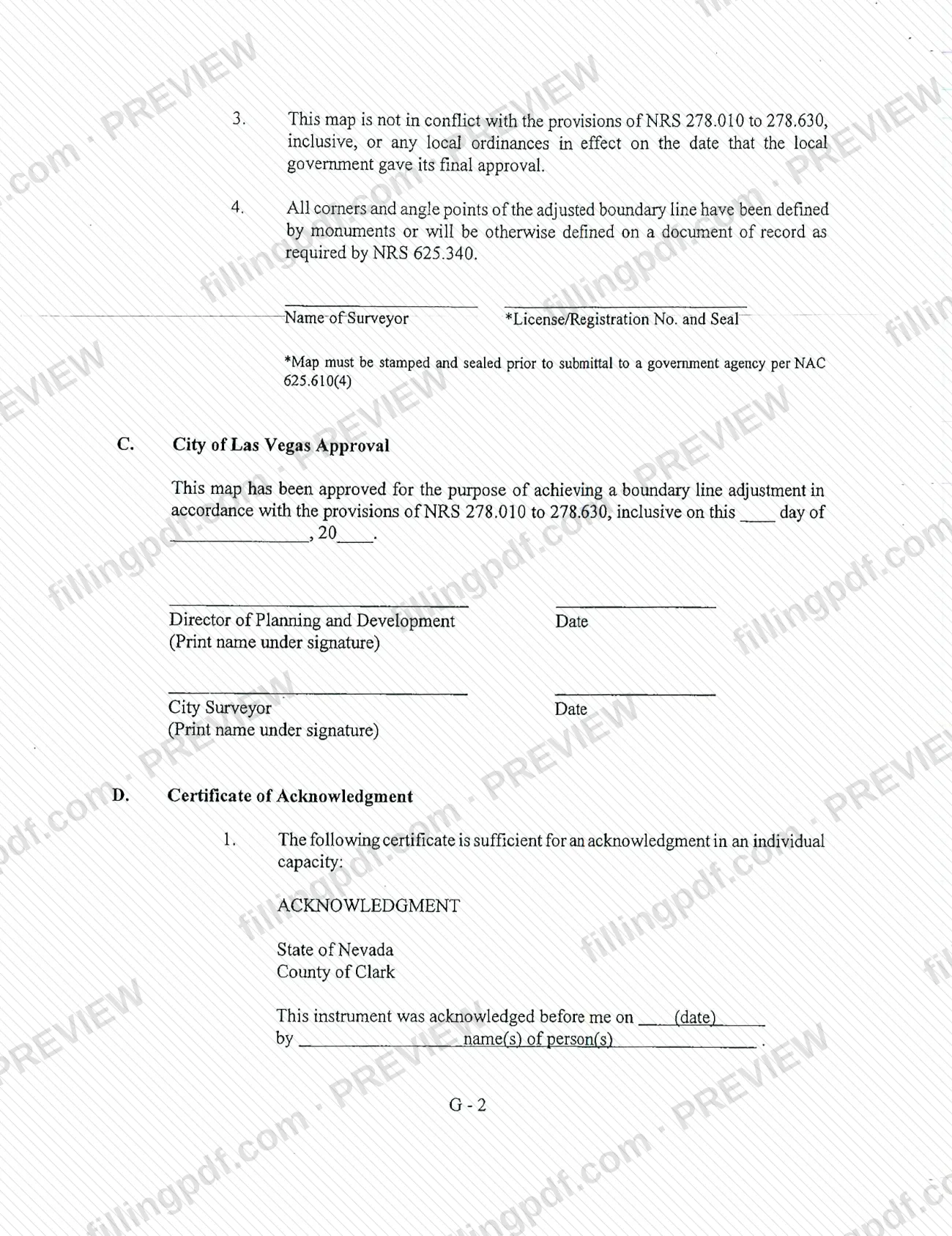
- Surveyor's Certificate. A Professional Land Surveyor licensed in the State of Nevada certifies the field survey, the Section, Township, Range and Meridian, the survey date, that the map does not conflict with NRS 278.010 to 278.630 or local ordinances, and that corners and angle points are monumented or will be defined on a document of record as required by NRS 625.340.
- City of Las Vegas Approval. The block for the Director of Planning and Development and the City Surveyor, each with a date.
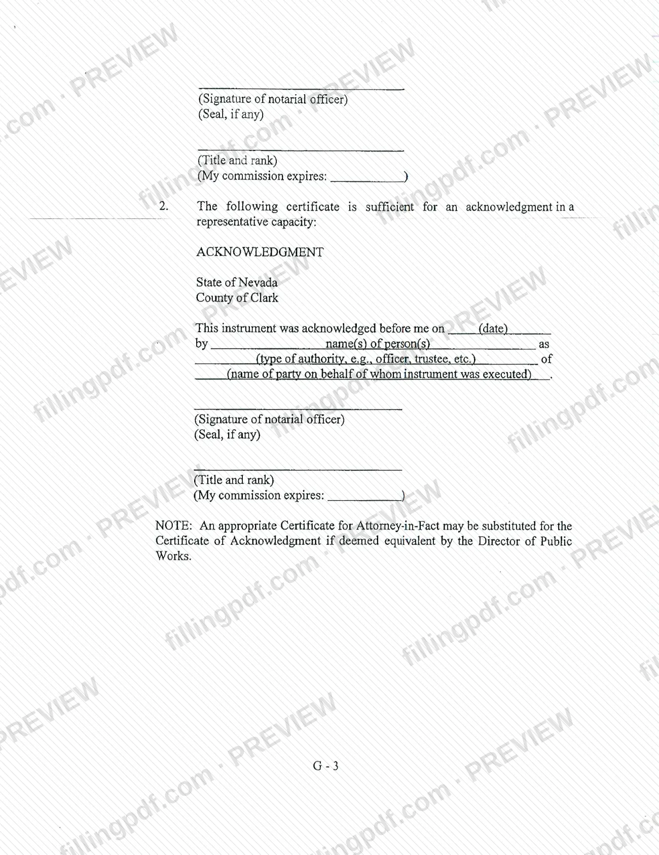
- Certificate of Acknowledgment. Notarial wording for an individual capacity and for a representative capacity, both under State of Nevada, County of Clark.
The Owner's Certificate is to be in substantially the printed form, with modifications the owner or map applicant makes to suit the project. The appendix is not a tax return or a tax payment form.
Who needs to file Appendix G?
The main users are owners or map applicants whose lands are shown on a record-of-survey map for a boundary line adjustment in the City of Las Vegas. They use the Owner's Certificate to approve the map, consent to its recordation and make the stated agreements about easements, taxes and lender notification.
Other people complete their own blocks:
- A Professional Land Surveyor licensed in the State of Nevada completes the Surveyor's Certificate, adds the license or registration number and applies the seal.
- A notarial officer completes the Certificate of Acknowledgment for the person or persons signing, in an individual capacity or in a representative capacity (for example officer or trustee).
- The Director of Planning and Development and the City Surveyor sign the City of Las Vegas Approval block; the owner does not complete it.
An attorney-in-fact may be covered too: the appendix says an appropriate Certificate for Attorney-in-Fact may be substituted for the Certificate of Acknowledgment if the Director of Public Works deems it equivalent.
This appendix is for boundary line adjustment maps only. It is not a property tax bill, return or payment form.
When to file Appendix G
The certificates are completed when the record-of-survey map for the boundary line adjustment is prepared, because they are printed on that map. The appendix sets no separate due date. Two timing points are stated: the map must be stamped and sealed before it is submitted to a government agency, per NAC 625.610(4), and the Surveyor's Certificate records the date the survey was completed. The Owner's Certificate is dated with the day, month and year it is signed. The City of Las Vegas Approval block is dated by the Director of Planning and Development and the City Surveyor when the city approves the map, and the acknowledgment records the date it was made before the notarial officer.
Documents you need
- The record-of-survey map for the boundary line adjustment, which carries these certificates; it must be stamped and sealed before submittal to a government agency.
- The surveyor's license or registration number and seal, entered with the Name of Surveyor on the Surveyor's Certificate.
- A completed Certificate of Acknowledgment, in an individual or representative capacity, signed and sealed by a notarial officer for each person signing.
- A Certificate for Attorney-in-Fact, only if substituted for the Certificate of Acknowledgment and deemed equivalent by the Director of Public Works.
How to fill out Appendix G
Enter the owners' names
In the Owner's Certificate, enter the name of each owner of the lands shown on the map, at the opening line before "do hereby certify." Adapt the wording to the project only as the owner or map applicant needs.
Date the Owner's Certificate
Complete "Dated this ___ day of ___ 20__" with the day, month and year the owners sign. Each owner signs only after the easement, tax and lender-notification statements are true.
Enter the surveyor's name
In the Surveyor's Certificate, enter the name of the Professional Land Surveyor licensed in the State of Nevada at the opening line.
Name the owner or map applicant
In item 1, enter the owner or map applicant at whose instance the field survey was conducted.
Enter the location and survey date
In item 2, enter the Section, Township, Range and Meridian where the lands lie, and the date the survey was completed.
Add the surveyor's license number and seal
Beside the Name of Surveyor, enter the License/Registration No. and apply the seal. The map must be stamped and sealed before submittal to a government agency.
Leave the City approval block blank
The City of Las Vegas Approval block, with the Director of Planning and Development and the City Surveyor lines, is signed and dated by the city, each with a printed name.
Complete the acknowledgment wording
Choose item 1 for an individual capacity or item 2 for a representative capacity. Enter the date and the names of the persons; for item 2 also enter the type of authority and the party on whose behalf the instrument was executed.
Leave notarial lines to the notary
The notarial officer adds the signature, seal if any, title and rank, and the commission expiry date.
Review and download the completed PDF
Check names, dates, the Section, Township, Range and Meridian and the license number, then download or print the completed PDF from FillingPDF.
How to submit Appendix G
Appendix G is not sent on its own: its certificates are placed on the record-of-survey map for the boundary line adjustment, and the map is what goes to the city. The appendix prints no mailing address, portal or appointment rule.
- Before submittal: the map must be stamped and sealed by the surveyor before it is submitted to a government agency, per NAC 625.610(4).
- City approval: the City of Las Vegas Approval block is signed by the Director of Planning and Development and the City Surveyor, so leave it for them.
- Where to ask: the City of Las Vegas Department of Planning publishes the appendix at https://files.lasvegasnevada.gov/planning/Title-18-Appendix-G.pdf; contact the department for the current submittal procedure for boundary line adjustments.
FillingPDF lets you fill out and download the PDF; submission follows the channels of the City of Las Vegas.
Common mistakes to avoid
- Submitting the map to a government agency before the surveyor has stamped and sealed it, which NAC 625.610(4) requires first.
- Leaving out the surveyor's license or registration number and seal beside the Name of Surveyor.
- Signing the Owner's Certificate while taxes on the lands shown are unpaid, or before lenders and impound account holders have been notified of the adjustment.
- Omitting the Section, Township, Range, Meridian or the survey completion date in item 2 of the Surveyor's Certificate.
- Filling in the City of Las Vegas Approval block yourself instead of leaving it for the Director of Planning and Development and the City Surveyor.
- Using the individual-capacity acknowledgment when a person signs for a party, such as an officer or trustee, where the representative-capacity wording applies.
- Substituting an Attorney-in-Fact certificate without confirming that the Director of Public Works deems it equivalent.
- Leaving the acknowledgment date, the names of the persons or the notary's commission expiry blank.
Frequently asked questions
What is Appendix G, Required Certificates, for a boundary line adjustment?
It is the City of Las Vegas Department of Planning appendix that gives the wording of the certificates printed on a record-of-survey map for a boundary line adjustment: the Owner's Certificate, Surveyor's Certificate, City of Las Vegas Approval and Certificate of Acknowledgment.
Is Appendix G a property tax form?
No. It is a map certificate. Its only tax-related wording is in the Owner's Certificate, where the owners agree that all taxes on the lands shown have been paid and that lenders and impound account holders have been notified of the adjustment.
Who signs the Surveyor's Certificate?
A Professional Land Surveyor licensed in the State of Nevada. The surveyor certifies the field survey was done under direct supervision, enters the license or registration number and applies a seal. The map must be stamped and sealed before submittal to a government agency, per NAC 625.610(4).
Who completes the City of Las Vegas Approval block?
The city does: the Director of Planning and Development and the City Surveyor each sign, date and print a name under the signature. The map applicant or owner does not fill in this block.
Which acknowledgment do I use, individual or representative?
Use item 1 when a person signs in an individual capacity. Use item 2 when a person signs as an officer, trustee or other authority for a party; it adds the type of authority and the name of the party on whose behalf the instrument was executed.
Can an attorney-in-fact certificate replace the acknowledgment?
Yes, but only if the Director of Public Works deems it equivalent. The appendix says an appropriate Certificate for Attorney-in-Fact may be substituted for the Certificate of Acknowledgment under that condition.
Where do I send Appendix G?
The appendix prints no address or portal. Its certificates go on the record-of-survey map, which must be stamped and sealed before submittal to a government agency. Contact the City of Las Vegas Department of Planning for the current submittal procedure.
Can I fill out Appendix G online on FillingPDF?
Yes. You can fill out the PDF online on FillingPDF and download or print it. FillingPDF is independent of the City of Las Vegas and does not file or submit the map; you submit it through the city's channels.
Ready to fill out Appendix G?
Fill out Appendix G now